Blood Mountain Wilderness Area
Part of the Chattahoochee
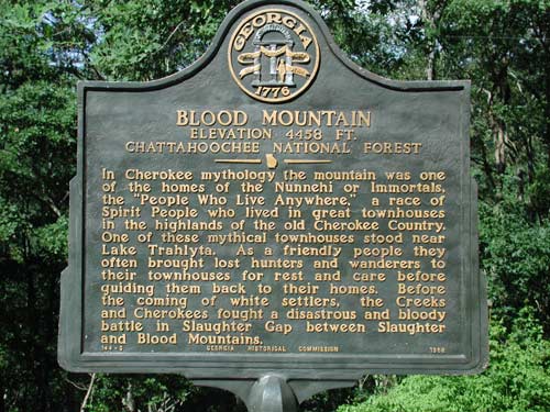
National Forest , Blood Mountain is the highest peak on Georgia's
portion of the Appalachian Trail and the state's sixth highest mountain.
Congress designated the Blood Mountain Wilderness Area in 1991 and
it now has a total of 7,800 acres which is managed by the U.S. Forest
Service. The Wilderness is the first designated wilderness area along
the Appalachian Trail as the hiker heads north toward Maine.
Legends tell the origin of the mountain's name
could have come from the disastrous and bloody battle between Creek
and Cherokee Indians in Slaughter gap between Slaughter and Blood
Mountain. Other theories trace the name to red lichen or Catawba rhododendron
growing on the rocky summit.
At 4,458-foot Blood Mountain the site is the
highest point in this Wilderness. Scenically rugged mountain peaks,
rocky outcroppings, waterfalls, and numerous streams (offering 27
miles of trout fishing), all of which lie within the Chestatee Wildlife
Management Area, surround the mountain. Deer, grouse, wild turkeys
and squirrels live here in abundance with lesser numbers of black
bear and raccoons. On the boundary you'll find the
Desoto Falls Scenic Area with its high vista points and waterfalls.
Many old logging roads crisscross the area. Just across US 129 lies
the Raven Cliffs Wilderness.
Hikers usually travel the Appalachian Trail,
which crosses the area along the crest of the Blue Ridge for 10.75
miles. On the AT on Blood Mountain a rock shelter stands, and of this
trail the USFS says: " . . . the most heavily used portion of
the AT in Georgia." The Duncan Ridge National Recreation Trail
crosses part of the area and several other forest service pathways
provide access to more remote regions.
Activities: Pioneer and primitive campsites, cottages,
picnic shelters, group shelter, CCC museum, general store, miniature
golf, 20-acre lake, pedal boat rental, swimming beach, fishing and
17 miles of backpacking and hiking trails.
Facilities: 233 acres. 85 tent, RV and trailer sites,
18 walk-in campsites, pioneer and primitive campsites, 35 cottages,
4 picnic shelters, 1 group shelter, CCC museum, general store, miniature
golf, 20-acre lake, pedal boat rental, swimming beach, and 17 miles
of backpacking and hiking trails.
Fees: call
Closest town:
Blairsville, Georgia
For more information:
Please say you saw it on
www.GreatGeorgiaProperties.com!
Vogel State Park
7485 Vogel State Park Road
Blairsville, GA 30512
Reservations (800) 864-7275
Park Office (706) 745-2628
